August 22, 2011 [CLICK HERE to see proper format.][LINK / comment]
Midwest photos: cities and floods
This year's batch of photos from my travels to the Midwest has two main themes: urban centers and floods. It was the first time I had really stopped to look around (and photograph) the downtown sections of Indianapolis, Kansas City, and Saint Louis. In each case I came across interesting scenery, a combination of vibrant new structures and crumbling old factories. The Rust Belt! In the latter two cities, searching for the sites of former baseball stadiums led me to discover some charming but rather run-down neighborhoods. [One especially sad scene was the ongoing demolition of Holy Name Catholic Church, in Kansas City, about a half mile from where Municipal Stadium used to be. It was a beautiful old stone structure, but the congregants had evidently moved far away several decades ago, and nobody seems willing or able to maintain or restore it.]
The other theme was the floods all along the Missouri River, which was supposed to be protected against such natural disasters by the advent of large dams that were built in the decades following World War II. I was aware that Interstate 29 had been closed in the vicinity of Omaha, Nebraska, but I assumed the waters would have receded by now. Wrong! To my surprise, on my way out west I had to drive through several low-lying sections of I-29 that are still protected by sandbags on either side, with the flood right next to the road bed. Yikes! Low-lying parts of Sioux City, Iowa remains inundated as well, I learned. As I was heading toward Kansas City on my return trip, I had to take an extensive detour through southwestern Iowa along U.S. Route 71 because I-29 is still closed south of Omaha! To me, that is almost incomprehensible.
While sight-seeing in South Dakota, I was astonished by the enormous volume of water that is being released at the Gavins Point Dam. (See below.) Those in charge of managing the Missouri River dams did not anticipate the consequences of the above-average winter snowfall, combined with a very rainy spring. (Your government in action.  ) I learned that the 1944 "Pick Sloan Plan" (named after an Army Corps of Engineers general who had a zeal for damming rivers) was never fully thought through in advance. This year we learned that the ability of human beings to control the natural environment through dams, etc. is more limited than we would like to think. For both points of view, see the Corps of Engineers Web site and Prairie Fire, a progressive (leftist) newspaper based in Lincoln, Nebraska.
With that as background preparation, please take a look at the brand-new Midwest 2011 photo gallery.
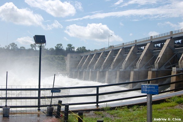
The Gavins Point Dam, which has been overflowing all summer. It is located about five miles west of Yankton, South Dakota.